Thomas Hart Benton Stasey is shown above (right) with two unnamed compatriots. They are, presumably, members of "Stasey's Rangers."
Thomas Hart Benton Stasey (hereafter referred to as THBS) was fatally wounded at the battle of Pierce’s Mill in Scotland County, Missouri, on July 18, 1862, at a point on the Fabius River near the Keokuk and Western Railway.
The above picture links to a more recent analysis of the battle, including a better understanding of its more precise location. Research has advanced since this page was drafted, but mysteries remain.
A force of
500 Federal troops under Major Clopper met a force of 200 Confederate troops
under Colonel Joseph C. Porter. The
Union troops were victorious but suffered severe casualties. The confederates attacked from ambush. The battle is also called the Battle of
Vassar Hill (Mt Pleasant Twp, 64N-Rg7-12W). The
nearest settlement in the area is Bible Grove, Missouri. It formerly had a post
office, but now consists of a few houses, two churches, their attendant
cemeteries, and a school. The records of the battle consist of a few military
records written by the Union Army, some mentions in the county histories
written for the 1876 centennial, and a book, “With Porter in Northern
Missouri,” written by Joseph Mudd in 1901. Mudd rode with Porter, took part in
the battle and continued south with him as he eluded the following Union
forces. Mudd’s account is by far the most detailed, and has the only known
account of THBS’s death.
 |
The topographical map, left, is provided from, and linked to, another web site containing detailed analysis of the battle site. Further pictures and maps provided by the same researcher are available at http://public.fotki.com/iowaz/scotland-co-mo/battle-of-vassar-hill/. |
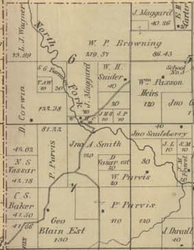
THBS’s great-great grandsons recently (June, 2015) visited the site of the battle. Plat maps of the area are available for the years 1858 (four years before the battle), and 1876 (fourteen years afterward). The 1858 maps show land ownership but not roads, streams and towns. These artifacts are available on the 1876 maps.
 |
The map at left is a composite constructed from two, adjacent Scotland County plat maps from the 1858 series. The picture is linked to the full plat map book. The left side of the composite is from Township 64, Range 13, the right side is from Township 64, Range 12. |
 |
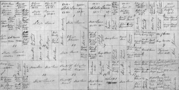
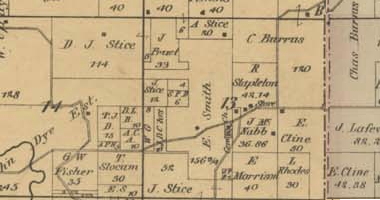
This map
is a composite of the 1876 plat maps showing the same area as the map above. It
is linked to the full book of 1876 plat maps. Bible Grove is depicted by the dot in the lower right corner of section 12 on the left side of the composite. The bridge over the Fabius River is shown in section 7 on the right side of the composite. |
 |
At left
is a detailed picture of the battle area, showing the location of the Maggard
property, where the Union casualties were buried, and the road from the bridge over the North Fork of the Fabius River, down the length of Vassar Hill Road. The road today follows the left (westward) branch in the Jno A. Smith property toward the southwest corner of the map, and Bible Grove. The eastern branch going between the P. Purvis and Geo Blain properties does not exist today. The tiny dot northwest of the river crossing, at the sharp jog in the road, may have been the location of Pierce's Mill. |
 This map is a detail of the 1876 plat maps showing the likely route taken by Porter as he left the Vassar Hill Area. |
In 1858, and presumably 1862, the date of the battle, the west half of section 13 was owned by Rudolph March. A road passes directly through the area to a crossing of the Fabius River. Mudd mentions fording the Fabius at a location above the main Kirksville road. That may have been the route branching south through the J. Stice property. It crosses the same river below the presumed Porter fording location. |
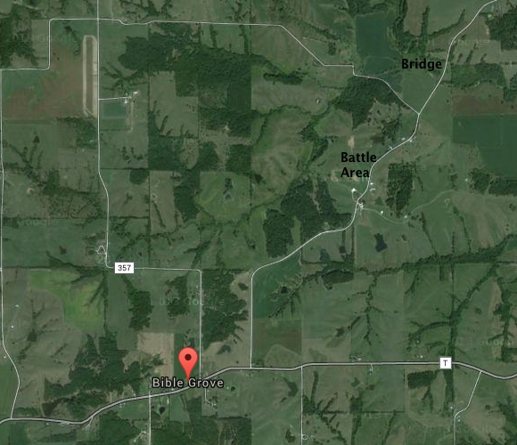 |
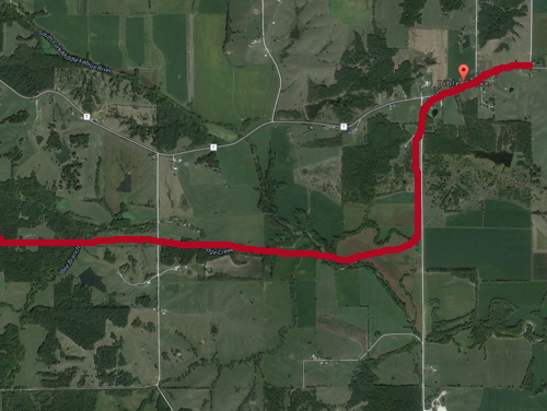
At left is a modern satellite map of the battle area. The current bridge over the Fabius is shown in the upper right. The battle is presumed to have occurred someplace along Vassar Hill Road, on the way to Bible Grove. Mudd says they rode two to two and a half miles from the bridge in setting up the ambush. That distance would have taken them almost to Bible Grove. The Union accounts make it sound like the distance was much shorter. |
A comparison of plat maps to Mudd’s account reveals problems. Mudd says Porter’s men crossed the “Fabius Creek” bridge, rode about two or two and a half miles further , and established an ambush. From his description it is clear they were on the west side of the road. The Federal soldiers were fired on and retreated back down the road to “a dim road” that led them back to their command. Porter’s men repositioned half a mile northward, single file with about six to ten feet between them. A glance at the maps shows a problem with Mudd’s distance estimates. The village of Bible Grove was two and a half miles south of the Fabius bridge. If the ambush had occurred in Bible Grove, that fact would surely have been noted.
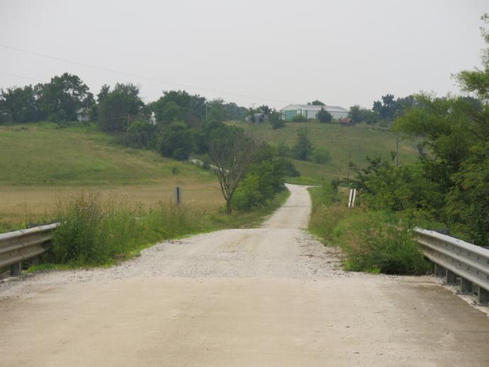
On a recent visit to the area, THBS’s great-great grandsons viewed the ambush site. This picture below, taken from the current Fabius River bridge, shows a perfect ambush location, where the road bends and ascends up a steep incline. It is about a quarter mile from the bridge. Mudd’s description makes it clear Porter’s men took the horses up the road, hid them in the trees, and went back to their ambush location. Mudd says he was on the right of the line, furthest from the enemy. This makes it apparent the ambush was from the right (west) side of the road in the picture below. After the first volley, after the Federals retreated, Porter ordered the men half a mile north, closer to the enemy, for the second Federal charge. Mudd says they didn’t quite make it that far, owing to various difficulties. It was from that second location that the Union soldier, Stillson, had his horse shot from under him. THBS was attempting to get the horse off of Stillson, when he was fatally wounded. A description of this event is provided by Stillson himself, via Mudd, in Mudd’s book.
 |
We, THBS’s grandsons, speculate that the most likely spot for this second ambush site was on the slope ascending out of the Fabius River bottom land. The pictures below show one of THBS’s grandsons walking north along the road at what may have been the location of the battle and was perhaps close to the spot THBS was wounded. The speculation is that the Federals charged up this hill and were fired on by Porter's men from the west side of the road (on the right in the next picture and on the left in the two below it).
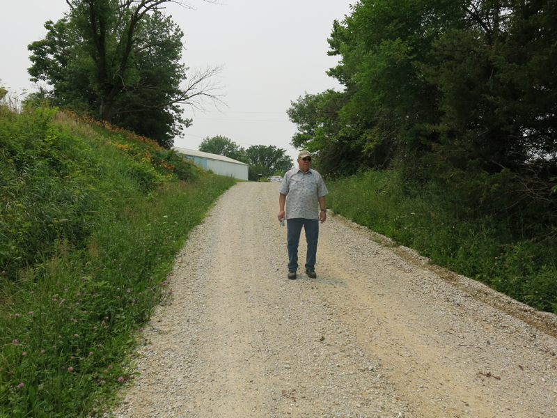 |
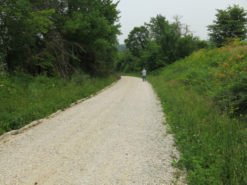 |
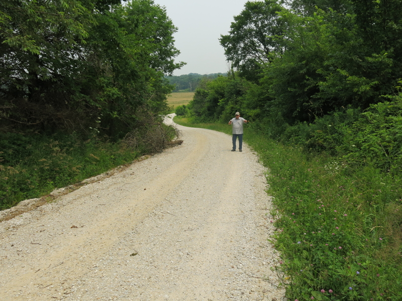 |
After the battle, Porter headed for
Kirksville and then went on south. The travel and subsequent skirmishes are
described in Mudd’s book. Mudd says THBS was left along the way, prior to
fording the Fabius. Records of the Rudolph March family say THBS died two days after
the battle at the home of Rudolph March. As can be seen in the 1858 Plat Map,
with reference to the road shown on the 1876 map, March owned property through
which Porter’s men probably traveled.
 |
The exact location of the Rudolph March house, called a log cabin in the family’s records, is not known, but it seems likely it lay along the road Porter took in leaving the area, and that THBS was left there when it was decided he couldn't survive the trip. The above satellite photo shows how Porter may have proceeded, after the battle, across Rudolph March's land. The March house is probably where THBS’s widow went to retrieve the body. It is not known where THBS is buried but we know his young daughter was buried, one month after his death, in the Howe cemetery near where the widow’s parents lived. The daughter’s grave is marked and there is an unmarked grave beside it (there are many unmarked graves in Howe Cemetery). It is reasonable to speculate the child was buried beside her father.
The map below gives the chronology and geography of Porter's retreat from Memphis. Priscilla Stasey is buried a few miles north of Monroe City. THBS lived a few miles north of Hunnewell. Porter's force was eventually cornered and he escaped south, scattering his recruits. The map links to an account of the Civil War in Northeast Missouri, and gives an overview of Porter's exploits. The document will open in a separte window. When it does, click on the button labeled "next" to advance to the next page.